Rasor Road offers a wide range of terrain for
off road exploration. From sand dunes, hard
pack, rock and hill climbs. There is
something for everybody.
off road exploration. From sand dunes, hard
pack, rock and hill climbs. There is
something for everybody.
| Host |
| Last Changed 1/24/2022 |

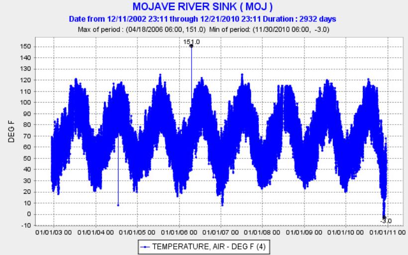
| UPDATE JANUARY 24TH 2022 I hope everyone had a nice Christmas and New Years holiday Rasor Road received much rain over that period and hopefully will lead to a bountiful spring wildflower bloom. Hope to see you out there. Take care, Tim UPDATE JANUARY 2018 The road into camp is a little soft just before you enter the camping area but there are three or four lines, one should get you to the camping area so choose wisely :). It's very dry out here so expect dust if exploring in a group. Beautiful weather though. Hopefully we will see some rain before spring. Take care and see you at Rasor, Tim UPDATE 1/2/2014 Latest Road Conditions Jan 2014 The road into camp was in great shape. Good moisture just under the surface makes for good traction. Be sure to stay on the well traveled road with your motor home or trailer as it is still soft enough to get stuck in the sand if you blaze your own trail. The Shell Gas Station at Rasor Road is doing banner business with the folks traveling to and from Vegas. Lines for fuel and the restroom are very long. It's all good as long as the gas station remains open for us off-roaders. I have updated a few photos of Afton and corrected a few broken links. I will be adding some more pages and photos soon. Check back often. Hope you enjoy the website. Look forward to hearing from you, drop me an email. Take care, Tim tim@rasorroad.com Road Condition Update 2012 It looks like the road was packed well during the Thanksgiving holiday. No problems were reported. The Mojave River is running at the 17 FT. level near Victorville. Should make for some interesting rides in Afton Canyon! It has been very cold at night, so keep your batteries charged and propane tanks full. See the temperature graph below - Global warming, yea right! Tim We all miss you Guy! Your memory lives on in our hearts. Rasor just is not the same without you. Guy's photos of our '05 potluck - Click Below THANKSGIVING POTLUCK PHOTOS 2001 Kati wrote in with some Rasor Family History: Clarence McAlliff Rasor was my grandfather on my father's side. He was a surveyor for the Tonopah and Tidewater Railroad that ran through the Baker area transporting bentonite and borax. Rasor was the name of one of the water stations along the route, in honor of him. I've never been to see it, but my brother has. There used to be a few buildings, but they are all gone. The T&T was closed down in about 1940. If you "google" Clarence Rasor (www.ttrr.org/img_dbf/shosh_01.html) you will find a website that gives the history of the Tonopah & Tidewater. There is a picture of my grandfather standing next to some of the people on the last train ride. Somewhere in this house I have a picture of him and a newspaper article about him. I once stopped at the Rasor Rd. Beacon Station and had promised myself I'd send a copy of the both so they could hang it in the cafe. Always nice to know a bit a of local history. But, here I am, three years later... 6 years ago, I rode my horse from Barstow to Laughlin, NV and passed over the old RR bed of the T&T. I stopped and got off my horse and had my picture taken of me standing on it. I found a few splinters of old railroad ties, kept one as a souvenir. I'd love to have a RR spike, but with the war in the early 40's, I'm sure all were scrapped and used for the war effort. I'll have to rummage around in the family photos to find a picture. Kati Thanks for the History - I hope you will find us a photo of your grandfather to post. Tim UPDATE 1/26/05 Melissa Eickhoff wrote in about her 1/15/05 visit. She said:"There are places where the river flowed a quarter mile wide!" Melissa included some photos. See the photos here |
| RASOR ROAD INFORMATION, WEATHER, ROAD CONDITIONS AND PHOTOS. WWW.RASORROAD.COM or WWW.RASOROAD.COM |
| WEATHER LINKS |
| Links VISIT OUR FRIENDS AT: |
| PHOTOS |